History of Niles' Street Names
Click on any photograph to view a larger image.
To
purchase a high-resolution print of any photograph on this page without
the visible watermark, E-Mail
Us
Use the image ID Example: PO1.1023
| E-Mail Us | Phone: 330.544.2143 | Mail: PO Box 368 Niles, Ohio 44446 |
 |
 |
 |
 |
 |
Niles Historical Books for sale
|
Betty Moritz wrote the following article, which was published in the Niles Times in 1980. Next time you drive around Niles, note the street signs and think of the history behind each one.
James Heaton built a stone dam across Mosquito
Creek and diverted water into a ditch or chase that ran parallel
to the creek until it reached the original grist mill where it
powered a water wheel to grind the seeds. If the iron and steel
mills were on a street, call it Furnace Street. The early mills,near
the Mahoning River, used furnaces to melt ore to make iron and
steel. These two streets, including the curve that joined them
together, would later be renamed State Street. |
|||
|
|
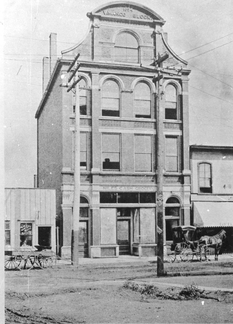
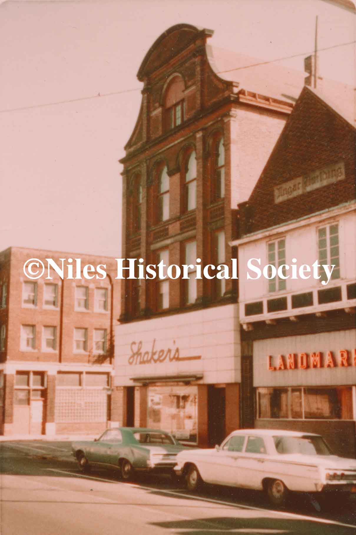
The Mango Block Building was built in 1894 by Vincent Mango and Park Avenue ended at Furnace Street (later named State Street). Later (1905) the small wooden building (left) was torn down to provide space for a bridge across Mosquito Creek. Isaac Shaker and Joe Abraham, two Lebanese immigrants, bought and remodeled it in 1913. In 1923 that partnership dissolved and the Shaker family maintained the clothing store until 1966 when it was torn down. |
|
|
| |
|||
|
At various times, it housed the Dollar Savings Bank, Home Federal Savings Bank and The Girl Scout Council. This building is also known as the Hartzell Building.
If laborers walked morning and night to their jobs at the iron furnace, who can fault calling the route they took Furnace Street? And wasn’t it logical to refer to the road that crossed the river and tied the new town to the settlements north and south as Main Street? And the one that led traffic past the park and the town hall, Park Avenue…and into Warren, Warren Avenue? Theirs was a life of practicality – no frills, no nonsense.
When land was given for a church to be built, the corner was labeled Church Street. In the railroad heyday, city fathers thought it fitting to have both an Erie and a Depot Street. Names like Vienna Avenue, Salt Springs Road, McDonald Avenue, North Road, South and West streets acted as compasses for those hardy immigrants.
A most intriguing way to learn about
the people who built this city is to research its street names.
Harmon Heaton, Pew, Hyde, Pratt, Allison, Battles are a partial
listing of Niles’ earliest families. Memories of those long
ago merchants and industrialists still live in the cement markers
which read Ward, Crandon, Robbins, Russell, Bentley, Sayers, Mason
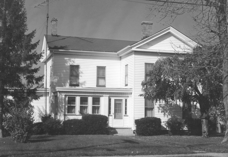
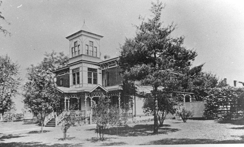
and Wood. Built before 1895 in the Italianate
Villa Style of Victorian architecture, it was the home of the President
of First National Bank, and later the home of Harry & Ethel
Mason Evans.
A little bit of reading discloses two Masons, H. H. and Ambrose, so the city map gives credit to both. The Bentleys were bankers. E. A. Gilbert and J. H. Baldwin were 19th century industrialists. Thomas Russell came from Lisbon in 1841, an associate of James Ward in the building of a furnace on the Mahoning River. Founder James Heaton’s story is a familiar one. Even the daughters of these early families have their names immortalized on city maps – Ann and Emma Streets, Helen and Margaret Avenues, Estelle Court and Eliza Alley. One, Mrs. Ann Mason Williams, could boast three times over.
W. C. Allison was a lumber yard operator and related by marriage to William McKinley. B. F. Pew was the organizer and first president of the Niles Board of Trade as well as one of the first trustees of Union Cemetery. J. K. Wilson was a town clerk and Misters Harris, Wagstaff, and Hartzell were well-to-do businessmen.
Prior to 1900, the list of local mayors
and postmasters include surnames, Davis, Leslie, Ohl, and Hunter,
as well as the more familiar, Mason, Robbins and Ambrose. Locating
their names on city maps indicates the growth of the city in all
directions and its emergence as a center of industry. Nationwide,
towns have customarily honored past presidents, and older Niles
was no exception. The street markers constantly remind us of such
great men as Washington, Lincoln, Grant, McKinley, Harrison, Madison,
Taft and Roosevelt. Colonial history was kept alive by our forebears
on such roads as Penn Avenue, Franklin Avenue, and Lafayette Street.
Proud of the role Ohio played in the Civil War, community officials
of that period were responsible for such markers as Stanton, Sherman,
and Sheridan. Little is left to remind us that the Indian did come
and go across our fields. Directories list a Seneca Street and an
Indian Trail. Do you suppose they trapped the beaver that gave their
name to Beaver Street? Pioneers of the early 1800’s found
northeastern Ohio a densely wooded region. Some of Niles’
first streets were named for trees; Cherry, Maple, Chestnut, Linden,
Poplar, Cedar and Hazel. More recent additions of this type are
Hickory Lane and Spruce Court.
A few of the early planners must have
had an affinity for the aesthetic because names like Pleasant, Woodland,
Fairlawn and Gardenland appear. Others used no imagination at all,
tagging streets with numbers, First, Second, Third and... The opportunity
to learn to read and spell the names of streets is as close to school
children as street signs that identify Indiana, Ohio, Nebraska,
Iowa, Wyoming and Dakota.
|
|||
| |
|||
| Continuing
with other Street names—
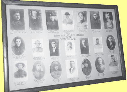
Few people knew that their street was renamed to honor the service people that died in World War I during 1918-1919 The following is a list of the names of those individuals in the picture. The picture is on display at the museum in the Westenfield Room. Click to view photographs of the soldiers who died in WW1 and had streets named after them, One of our readers has written that Victor Avenue was named after Victor Huber who died at Camp Sherman in 1919 and Sayers Ave. was named after Bill Sayers’s grandparents who lived on that street. Sam and Agnes Park had a large farm on both sides of the road that extended from the Mahoning River, west to the next crossroad so that was called Park Avenue. More recently the street that runs behind McKinley High School, formally know as Liberty Street, was renamed George Rowlands Street in honor of a very devoted handicapped football fan. Last but certainly not least, the street that runs from State Street to the police station was named Utlak Drive in honor of Officer John Utlak, a Niles police officer killed in the line of duty on December 8, 1982. |
|||
| |
|||
I thought I would share with you the actual names of the alleys. Did you even know they had names? This information came from the last map of Niles provided by the city to the Board of Elections. Since there are many, I have divided them up into five areas. — Rebecca Archer DePanicis The northern triangle made by Vienna Avenue and
Robbins Avenue.
The fourth area covers the downtown area from
the Mahoning River to the Conrail tracks:
|
|||